Reconstruct Tracks
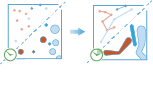
This tool works with a layer of point features or polygon features that are time enabled with time type instant. It first determines which features belong to a track using an identifier. Using the time at each location, the tracks are ordered sequentially and transformed into a line or polygon representing the path of movement. Optionally, the input may be buffered by some field, which creates polygons at each location. These buffered points, or if the inputs are polygons, are then joined sequentially to create a track as a polygon, where the width is representative of the attribute of interest. Resulting tracks have a start and end time, which represent temporally the first and last feature in a given track. When the tracks are created statistics about the input features are calculated and assigned to the output track. The most basic statistic is the count of the number of points within the area, but you can get other statistics as well.
For example, suppose you have GPS measurements of hurricanes every 10 minutes. Each GPS measurement records the hurricane name, location, time of recording, and the wind speed. You could create tracks of the hurricanes using the name of the hurricane as the track identification, and all hurricanes tracks would be generated. You can calculate statistics like the mean, max and minimum wind speed of each hurricane, as well as the count of measurements in each track.
Using the same example, you could buffer your tracks by the wind speed. This would buffer each measurement by the wind speed field at that location, and join the buffered areas together, creating a polygon representative of the track path, as well as the changes in wind speed as the hurricanes progressed.
Choose features to reconstruct tracks from
The point or polygon layer that will be reconstructed into tracks. You may optionally browse for a big data file share dataset or feature service layer.
Choose fields used to identify tracks
The field(s) that represents the track identifier.
As an example, if you were reconstructing tracks of hurricanes, you could use the hurricane name as the track field.
Choose method used to reconstruct tracks
Method used to join tracks and apply buffer (if applicable). The planar method may calculate the results more quickly, but will not wrap tracks around the international dateline or account for the actual shape of the earth when buffering. The geodesic method will wrap tracks around the date line if required, and apply a geodesic buffer to account for the shape of the earth.
Create an expression to buffer input features by (optional)
Equation used to calculate the buffer distance around input features. This equation can be generated using the buffer calculator, and basic operations like add, subtract, multiply and divide are supported. Values are calculated using the analysis coordinate system.
Select a time to split tracks by (optional)
Time used to split tracks. If input points or polygons have a longer duration between them than the time split, than they will be split into different tracks.
Add statistics (optional)
You can calculate statistics about attributes of numeric fields of the input layer such as:
- Count
- Mean
- Min
- Max
- Range
- Variance
- Standard deviation
You can calculate statistics about attributes of string fields of the input layer, such as:
- Count
- Any —This statistic is a random sample of a string value in the specified field.
Choose datastore
This is a temporary parameter for the Beta release to set the data store that results are saved to. Both data stores are part of ArcGIS Data Store. If you select the spatiotemporal data store, and do not have one installed the tool will fail.
Result layer name
This is the name of the layer that will be created in My Content and added to the map. If the layer already exists, you will be asked to provide another name.
Using the Save result in drop-down box, you can specify the name of a folder in My Content where the result will be saved.