Overlay Layers
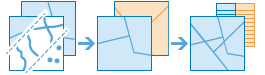
Overlay combines two or more layers into one single layer. You can think of overlay as peering through a stack of maps and creating a single map containing all the information found in the stack. Overlay is much more than a merging of line work; all the attributes of the features taking part in the overlay are carried through to the final product. Overlay is used to answer one of the most basic questions of geography, "What is on top of what?" For example:
- What parcels are within the 100-year floodplain? (Within is just another way of saying on top of.)
- What roads are within what counties?
- What land use is on top of what soil type?
- What wells are within abandoned military bases?
If Use current map extent is checked, only the features in the input and overlay layer that are visible within the current map extent will be overlaid. If unchecked, all features in both the input layer and the overlay layer will be overlaid, even if they are outside the current map extent.
Choose input layer
The point, line, or area layer that will be overlaid.
In addition to choosing a layer from your map, you can select Choose Living Atlas Analysis Layer or Choose Analysis Layer found at the bottom of the drop-down list. This opens a gallery containing a collection of layers useful for many analyses.
Choose overlay layer
The layer to overlay on the input layer.
In addition to choosing a layer from your map, you can select Choose Living Atlas Analysis Layer or Choose Analysis Layer found at the bottom of the drop-down list. This opens a gallery containing a collection of layers useful for many analyses.
Choose overlay method
The overlay method defines how the input layer and the overlay layer are combined.
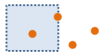
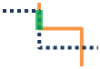
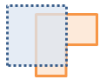
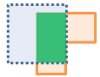
- Intersect—The result will contain only those features or portions of features in the overlay layer that overlap with features in the input layer. When intersecting line or area features, you have the option to specify the type of features you want as output.
Points with Points


Points with Lines


Points with Areas
Lines with Lines
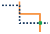
Lines with Areas

Areas with Areas
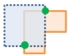
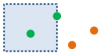
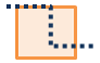
- Union—The result will contain features from both the input layer and the overlay layer. The Union option is only available if both the input layer and the overlay layer contain area features.
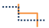
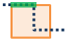
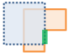
- Erase—The result will contain features or portions of features in the overlay layer that do not overlap with the areas in the input layer. The overlay layer can contain area, line, or point features.
If Use current map extent is checked, only the features in the input and overlay layer that are visible within the current map extent will be overlaid. If unchecked, all features in both the input layer and the overlay layer will be overlaid, even if they are outside the current map extent.
Result layer name
This is the name of the layer that will be created in My Content and added to the map. It will have the same feature type (areas, lines, or points) as the overlay layer. The default name is based on the overlay method and the input layer name. If the layer already exists, you will be asked to you will be asked to provide another name.
Using the Save result in drop-down box, you can specify the name of a folder in My Content where the result will be saved.