Create Buffers
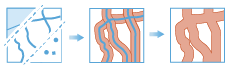
A buffer is an area that covers a given distance from a point, line, or area feature.
Buffers are typically used to create areas that can be further analyzed using other tools. For example, if the question is "What buildings are within one mile of the school?", the answer can be found by creating a one-mile buffer around the school and overlaying the buffer with the layer containing building footprints. The end result is a layer of those buildings within one mile of the school.
Choose layer to apply buffer to
The point, line or area features to be buffered.
In addition to choosing a layer from your map, you can select Browse Layers found at the bottom of the drop-down list to browse your contents for a big data file share dataset or feature layer.
Select the type of buffer to apply
There are three different ways you can specify the size of the buffer for your input features. You can buffer using a:
- Distance, where the same distance is applied to all features.
- You can specify an attribute on the input layer that contains the distance value by clicking field. You can use a string field or a numeric field. If a linear unit is not defined, the units of the spatial reference will be used. If you are using a geographic coordinate system, the unitless field will be assumed to be meters.
- You can build an expression with multiple fields and mathematical operators. When building an expression, numeric fields will be assumed to be in meters, and strings with a unit, such as "20Kilometers" will use the specified unit.
Select the buffer method
You can choose to use a Planar method or a Geodesic method. The Planar method may be faster, and is appropriate for local analysis on projected data. The Geodesic method is appropriate for large areas, and any geographic coordinate system.
Select the type of dissolve method
You may optionally dissolve your attributes. If you choose to dissolve all attributes or dissolve on a field you will be given the option of creating multipart or single part outputs. Dissolving aggregates features using the specified fields.
Allow multipart features
You can allow for multipart features. Single part features are the default.
Add statistics (optional)
You can calculate statistics about attributes of numeric fields of the input layer such as:
- Count
- Mean
- Min
- Max
- Range
- Variance
- Standard deviation
You can calculate statistics about attributes of string fields of the input layer, such as:
- Count
- Any —This statistic is a random sample of a string value in the specified field.
Choose datastore
This is a temporary parameter for the Pre-Release to set the data store that results are saved to. Both data stores are part of ArcGIS Data Store. If you select the spatiotemporal data store, and do not have one installed the tool will fail.
Result layer name
This is the name of the layer that will be created in My Content and added to the map. The default name is based on the tool name and the input layer name. If the layer already exists the tool run will fail.
Using the Save result in drop-down box, you can specify the name of a folder in My Content where the result will be saved.